
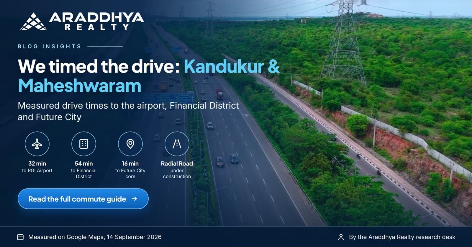
Commuting from Kandukur and Maheshwaram: Measured Drive Times to the Airport, Financial District and Future City
“Only 15 minutes to the airport” is the most common line in South Hyderabad property advertising, and the least tested. So we tested it. On 14 September 2026 we took the first route Google Maps suggested from two plot villages, Mohammadnagar in Kandukur and Pulimamidi, near Maheshwaram, to the places buyers actually commute to. Here are the results, including the Maheshwaram to Gachibowli distance, along with the method and the projects under construction that will change them.
Short answer: From Pulimamidi, near Maheshwaram, the Financial District near Gachibowli was 53.8 km and about 58 minutes by Google Maps’ first suggested route on 14 September 2026, via NH-765 and the Outer Ring Road. That run was outside the morning peak, so add 15 to 25 minutes for a weekday peak-hour trip into the IT corridor.
Key takeaways
- ✓Airport: about 32 minutes from Mohammadnagar (23.5 km) and 36 minutes from Pulimamidi (23.9 km).
- ✓Financial District: about 54 to 58 minutes (53 to 54 km) via NH-765 and the Outer Ring Road. Because the Financial District is near Gachibowli, the Pulimamidi figure doubles as the Maheshwaram to Gachibowli distance.
- ✓Future City core (Mucherla): about 16 minutes from Mohammadnagar and 24 minutes from Pulimamidi.
- ✓The Ratan Tata Radial Road (under construction as of September 2026) is the project most likely to change these numbers. In contrast, the airport metro is still proposed.
Measured drive times, including the Maheshwaram to Gachibowli distance
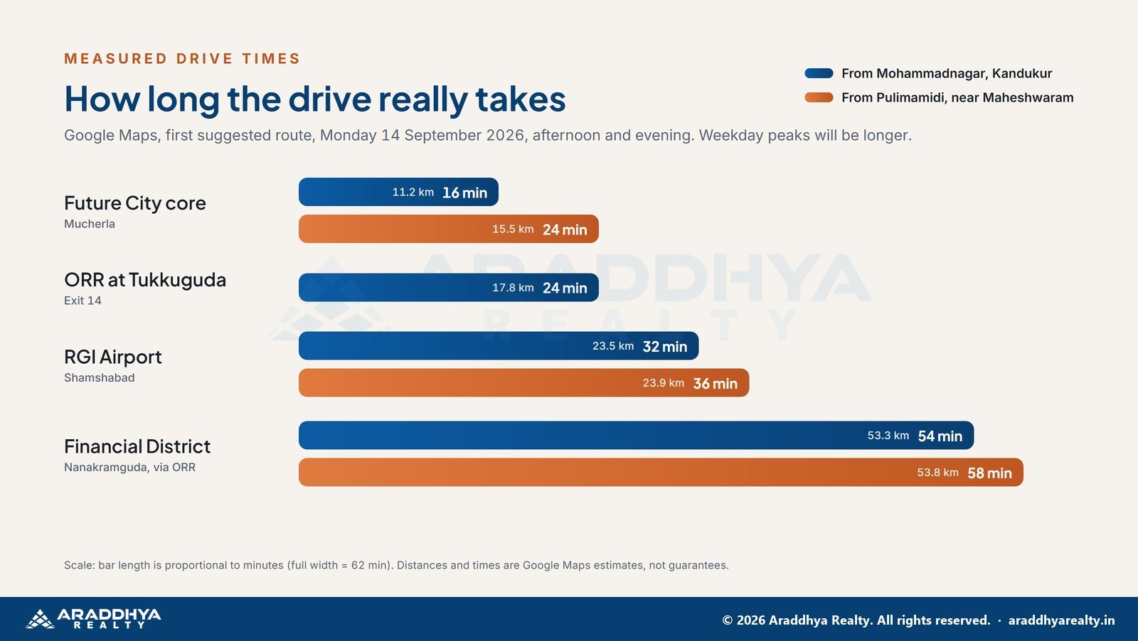
| From | To | Distance | Time |
|---|---|---|---|
| Mohammadnagar, Kandukur | Mucherla (Future City core) | 11.2 km | 16 min |
| Mohammadnagar, Kandukur | Tukkuguda (ORR Exit 14) | 17.8 km | 24 min |
| Mohammadnagar, Kandukur | RGI Airport, Shamshabad | 23.5 km | 32 min |
| Mohammadnagar, Kandukur | Financial District | 53.3 km | 54 min |
| Pulimamidi, near Maheshwaram | Mucherla (Future City core) | 15.5 km | 24 min |
| Pulimamidi, near Maheshwaram | RGI Airport, Shamshabad | 23.9 km | 36 min |
| Pulimamidi, near Maheshwaram | Financial District | 53.8 km | 58 min |
Method. Google Maps, first suggested driving route, measured on the afternoon and evening of Monday 14 September 2026. Weekday peak times will be longer, especially at ORR ramps and inside the city. So time the drive yourself at the hour you would actually travel.
More measured distances buyers search for
We timed these on Google Maps, first suggested route, on the evening of Sunday 27 September 2026. RGI Airport is at Shamshabad, so for Shamshabad to Kandukur use the Mohammadnagar row in the table above. For Maheshwaram, the nearest measured start is Pulimamidi, a Kandukur mandal village near Maheshwaram town.
| From | To | Distance | Time |
|---|---|---|---|
| Mucherla (Future City core) | Tukkuguda (ORR Exit 14) | 24.6 km | 35 min |
| Mucherla (Future City core) | RGI Airport, Shamshabad | 30.9 km | 47 min |
| Mucherla (Future City core) | Financial District | 60.8 km | 71 min |
| Kothur, Kandukur mandal | Tukkuguda (ORR Exit 14) | 12.8 km | 19 min |
| Kothur, Kandukur mandal | RGI Airport, Shamshabad | 19.1 km | 31 min |
| Kothur, Kandukur mandal | Kandukur village | 5.8 km | 13 min |
| Kadthal | Tukkuguda (ORR Exit 14) | 25.6 km | 34 min |
| Kadthal | Kandukur village | 10.1 km | 17 min |
| Kadthal | Mohammadnagar, Kandukur | 12.2 km | 17 min |
We have not yet timed Maheshwaram town, Tukkuguda village or Shamshabad town as start points. Village pages: Mucherla, Kothur and Lemoor and Yacharam and Kadthal.
How the commute actually works
To the airport
Both villages reach the airport along NH-765 to the ORR at Tukkuguda, then a short run west on the ORR to Shamshabad. There are no signals on the ORR itself. For that reason, this trip holds up well even at busy hours. Measured from Mohammadnagar, the Kandukur to airport distance is 23.5 km; from Pulimamidi it is 23.9 km. For frequent flyers and NRI owners, a half-hour airport run is therefore a real advantage.
The Maheshwaram to Gachibowli distance: Financial District and HITEC City
This is a long commute: around an hour in our measurement, and more at peak hours. Specifically, the Maheshwaram to Gachibowli distance, from Pulimamidi to the Financial District, was 53.8 km. The ORR does most of the work, but traffic backs up at the Gachibowli and Nanakramguda exits at peak hours. Buyers planning a daily IT-corridor commute should therefore weigh this honestly. In fact, many plot buyers here are building for the next decade, not for a daily drive today.
To Future City
From Kandukur, the new city is a local trip. We did not time the Future City to airport distance from Mucherla itself, so use the Mohammadnagar figures above as a guide. As the AWS data centre (under construction since the 15 July 2026 foundation stone), the TCS HyperVault campus (announced September 2026) and the Skills University campus (under construction as of September 2026) take shape, a growing share of jobs may sit south of the ORR rather than north of it. In short, that is the long-term commute argument for this belt.
Roads and transit that will change these numbers
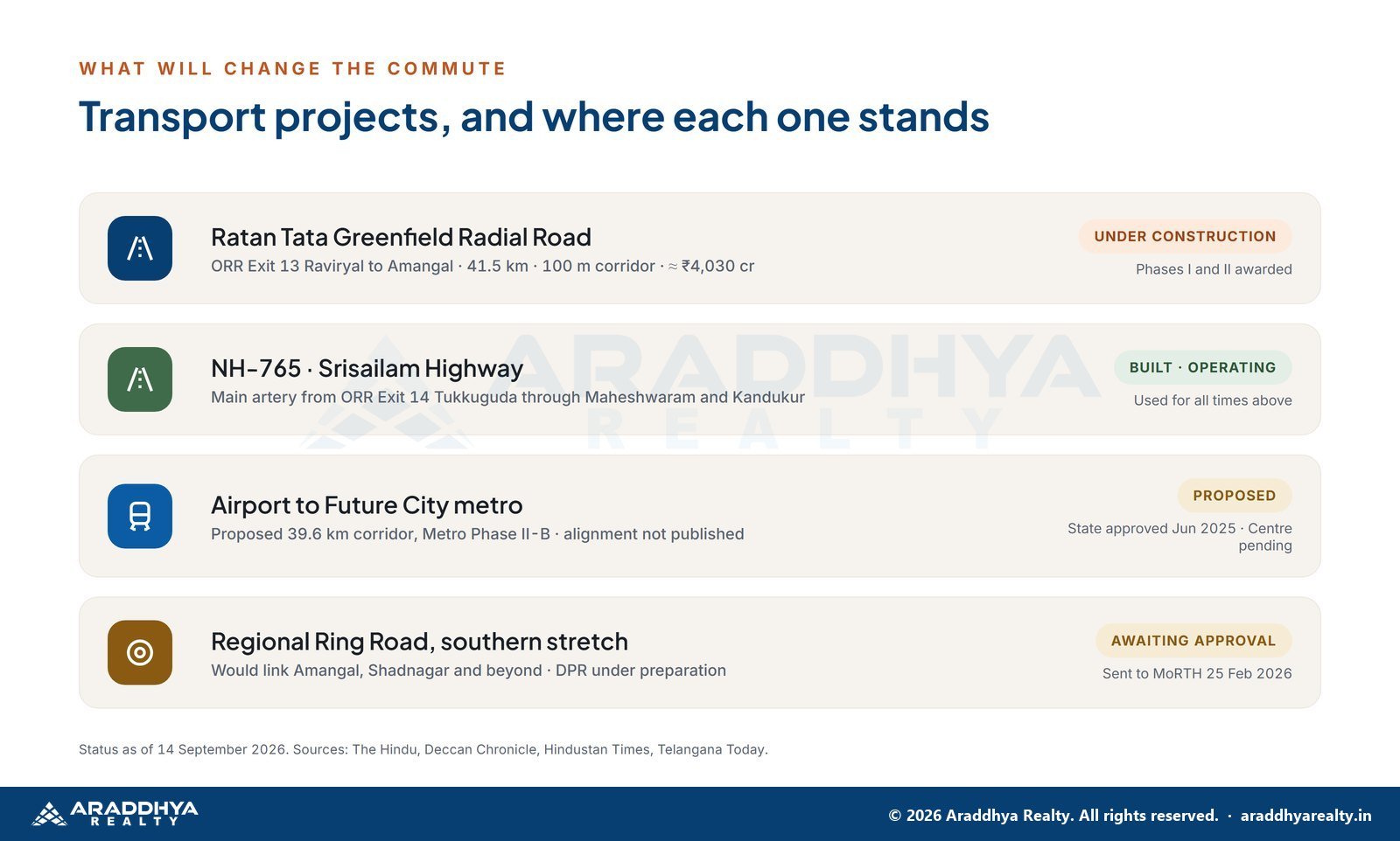
| Project | Status (Sep 2026) | Likely effect |
|---|---|---|
| Ratan Tata Greenfield Radial Road, ORR Exit 13 Raviryal to Amangal, 41.5 km | Under construction | A second, access-controlled link from Future City to the ORR |
| NH-765 corridor | Built, operating | Main artery today |
| Airport to Future City metro, 39.6 km | Proposed. State approved June 2025, central approval pending | Could change airport and city access, if and when approved |
| Southern Regional Ring Road | Awaiting central approval | Regional links; no timeline yet |
A weekday reality check on the Maheshwaram to Gachibowli distance
We took our numbers in the afternoon and evening of 14 September 2026, outside the morning peak. On a working day, however, three stretches decide how long the trip really takes:
- ORR ramps near Gachibowli and Nanakramguda in the morning peak, roughly 8:30 to 10:30 am, and again in the evening.
- The city end of NH-765 towards Chandrayangutta, if you are heading into the old city rather than onto the ORR.
- Village approach roads, which are narrow and slow even when the highway is clear.
A useful rule of thumb: add 15 to 25 minutes to any of our figures for a peak-hour trip into the IT corridor, then check it yourself. By comparison, the ORR section to the airport tends to hold up much better.
Getting around without a car
TGSRTC city and district buses run along NH-765, and app-based cabs and autos serve Maheshwaram and Kandukur, though waiting times are longer than inside the ORR. Frequencies vary by stop, so check the TGSRTC app for your exact village before assuming a daily bus commute works. A metro to Future City is proposed but awaits central approval, and the alignment is not yet public. For most buyers in this belt today, a car or two-wheeler is therefore part of the plan.
Three commute profiles
| You are… | Daily reality today | What improves it |
|---|---|---|
| Airport or Shamshabad professional | 30 to 40 minutes, mostly on the signal-free ORR | Already practical |
| IT professional in the Financial District, hybrid | About an hour each way on office days | Ratan Tata Road (under construction, Sep 2026) for Future City access; working from home the rest of the week |
| Future City or E-City employee (as those campuses open) | 15 to 30 minutes | New jobs moving south of the ORR |
Of the three, the hybrid IT professional feels the Maheshwaram to Gachibowli distance most, at about an hour each way on office days.
So, is South Hyderabad practical to live in?
It depends on where you work.
- Airport, Shamshabad, E-City or Future City: yes. Commutes of 15 to 40 minutes are realistic today.
- Gachibowli, Financial District, HITEC City: at 53.8 km, the Maheshwaram to Gachibowli distance makes this a long daily drive. As a result, many buyers treat a plot here as a medium-term home or a long-term holding while they live closer to work.
- Hybrid or remote workers: the trade-off favours larger plots and quieter surroundings over a daily commute you only make twice a week.
Whichever profile fits, check the project’s registration on the TG-RERA website before you book a plot.
Plan your next step
Time it yourself. Plan a weekday site visit and we will drive the route at the hour you would travel, with the clock running. In the meantime, see our Maheshwaram area page and plots near the airport, or book a weekday visit. Abroad or short of time? Walk each layout online first with our virtual site tours. Prefer WhatsApp? Message us on WhatsApp.
Frequently asked questions
From Pulimamidi, near Maheshwaram, the Financial District near Gachibowli was 53.8 km and about 58 minutes by Google Maps’ first suggested route on 14 September 2026. However, weekday peak times are longer.
From Mohammadnagar in Kandukur, RGI Airport was 23.5 km and about 32 minutes by car on 14 September 2026.
No. The proposed airport to Future City metro corridor still awaits central approval, and its alignment is not yet public, as of September 2026.
Today, NH-765 (Srisailam Highway) via ORR Exit 14 at Tukkuguda. In addition, the Ratan Tata Greenfield Radial Road from ORR Exit 13 at Raviryal is under construction as a second link, as of September 2026.
From Mucherla, the village most often named as the Future City core, ORR Exit 14 at Tukkuguda measured 24.6 km and 35 minutes on Google Maps on the evening of 27 September 2026, first suggested route along NH-765. Mohammadnagar in Kandukur measured 17.8 km and 24 minutes to Exit 14 on 14 September 2026. Peak-hour trips take longer.
Mohammadnagar in Kandukur mandal to RGI Airport at Shamshabad measured 23.5 km and 32 minutes on Google Maps on 14 September 2026, via NH-765 and the Outer Ring Road. Kothur, near Kandukur village, measured 19.1 km and 31 minutes to the airport on 27 September 2026. We have not timed a trip from Shamshabad town itself.
From Pulimamidi, a Kandukur mandal village near Maheshwaram town, RGI Airport measured 23.9 km and 36 minutes on Google Maps on 14 September 2026, first suggested route, via NH-765 and ORR Exit 14 at Tukkuguda. We have not timed the drive from Maheshwaram town itself, so time it at the hour you would travel.
From Pulimamidi, near Maheshwaram, Mucherla, the village most often named as the Future City core, measured 15.5 km and 24 minutes on Google Maps on 14 September 2026, first suggested route. From Mohammadnagar in Kandukur, Mucherla measured 11.2 km and 16 minutes on the same day.
Sources. Google Maps drive times measured 14 September 2026 · The Hindu and Deccan Chronicle on the Ratan Tata Road, 2026 · Hindustan Times and Swarajya on Metro Phase II approval, 2026 · Telangana Today on the Regional Ring Road, 28 April 2026.
This article is general information, not investment or legal advice. Figures are dated and change often. Verify approvals and project registration yourself at rera.telangana.gov.in and with the issuing planning authority before any purchase.
Useful next reads. the ten checks before you pay; how the southern corridors compare; which approval applies where; how to test a brochure claim; areas we cover; buyer questions answered; all our guides.
Disclaimer · Privacy policy · Terms of use · Araddhya Realty home