
Plots Near Hyderabad Airport in 2026: What Near Really Means, in Measured Minutes
You fly every other week, or you work shifts at the airport, or you are an NRI who wants the drive from arrivals to your own front gate to be short. Then a listing says “15 minutes from the airport”, and the price reflects it. This guide tests that claim for plots near Hyderabad airport: what the drive really takes from the villages buyers are offered, which authority approves each one, and the height and noise rules that come with living near a runway.
Plots near Hyderabad airport in short
Key takeaways
- ✓From five plot villages beyond the ORR, RGI Airport measured 30 to 36 minutes on Google Maps in September 2026, not 15.
- ✓The Outer Ring Road does most of the work: on our 14 September 2026 run, ORR Exit 14 to the airport took about 8 minutes.
- ✓AAI says no height NOC is needed below the colour-coded zoning map height, and none at all beyond 56 km of an instrument airport (NOCAS, checked 17 October 2026).
- ✓Since April 2026, new buildings near notified airport noise zones must use sound-resistant materials under G.O. No. 124.
What "near the airport" really means
Distance on a map is the wrong measure. What matters is minutes, at the hour you actually travel, from the plot’s gate to the terminal. Rajiv Gandhi International Airport (operator site) sits in Shamshabad mandal on the southern arc of the Outer Ring Road. From the plot villages along the Srisailam Highway (NH-765), the usual route runs north to ORR Exit 14 at Tukkuguda, then west along the signal-free ORR.
That has a useful consequence. The ORR stretch is quick and predictable; on our Mohammadnagar run of 14 September 2026, the car reached Exit 14 at 24 minutes and the airport at 32. So most of the time is spent on NH-765 and the village approach roads, and that is where two plots that look equally “near” on a brochure can differ by ten minutes or more.
Measured drive times to RGI Airport
We use the first route Google Maps suggests, outside the morning peak, and record the date. Here is every airport drive we have measured.
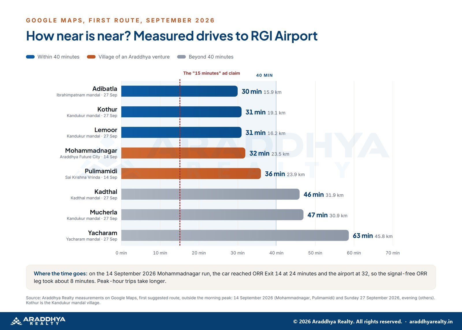
| From | Mandal | Layout authority | Distance | Time | Measured |
|---|---|---|---|---|---|
| Adibatla | Ibrahimpatnam | HMDA | 15.9 km | 30 min | 27 September 2026 |
| Kothur | Kandukur | FCDA | 19.1 km | 31 min | 27 September 2026 |
| Lemoor | Kandukur | FCDA | 16.2 km | 31 min | 27 September 2026 |
| Mohammadnagar | Kandukur | FCDA | 23.5 km | 32 min | 14 September 2026 |
| Pulimamidi, near Maheshwaram | Kandukur | HMDA | 23.9 km | 36 min | 14 September 2026 |
| Kadthal | Kadthal | FCDA | 31.9 km | 46 min | 27 September 2026 |
| Mucherla | Kandukur | FCDA | 30.9 km | 47 min | 27 September 2026 |
| Yacharam | Yacharam | Varies by village | 45.8 km | 63 min | 27 September 2026 |
Kothur here is the Kandukur mandal village, not the NH-44 town of the same name. The 27 September figures were taken on a Sunday evening, so weekday trips will often be slower. Our South Hyderabad commute guide explains the method.
The realistic options at 30 to 40 minutes
If your rule is “under 40 minutes to the terminal”, five villages in our measurements qualify. Each comes with a different authority and a different kind of neighbourhood.
Adibatla, 30 minutes
The closest in our table, on the Nagarjuna Sagar road side of the ORR. HMDA approves layouts here under G.O.Ms.No.68, and the former Adibatla municipality became part of GHMC in December 2025, so ask which body will issue your building permission. Our Adibatla area page covers it; we do not sell plots there.
Kothur and Lemoor, 31 minutes
Two Kandukur mandal villages in the FCDA area since 12 March 2025. Kothur also measured 19 minutes to ORR Exit 14, and our Kothur and Lemoor page has the full set of measured drives.
Mohammadnagar, 32 minutes
An FCDA village on NH-765, also 16 minutes from Mucherla, the Future City core. This is where Araddhya Future City sits: 6.5 acres, 76 plots, with an HMDA layout permission listed on its project page.
Pulimamidi, near Maheshwaram, 36 minutes
A Kandukur mandal village in the HMDA region, close to Maheshwaram town. This is where Sai Krishna Vrinda sits: 4 acres, 63 plots, under an HMDA layout permission.
Beyond 40 minutes, Kadthal and Mucherla both measured about three quarters of an hour. Shamshabad, beside the airport, is closer still; our Shamshabad airport belt guide and Shamshabad area page cover the villages around the runway.
Want the airport drive timed from a plot at your own travel hour? Book a visit and we will drive it with you, clock running, before you decide anything.
Height rules near RGI Airport: how to check a plot
Every plot in this belt sits well within 56 km of the airport, so aviation height rules apply in principle. In practice, they rarely touch a two-storey family home, but you should know how to check rather than take anyone’s word.
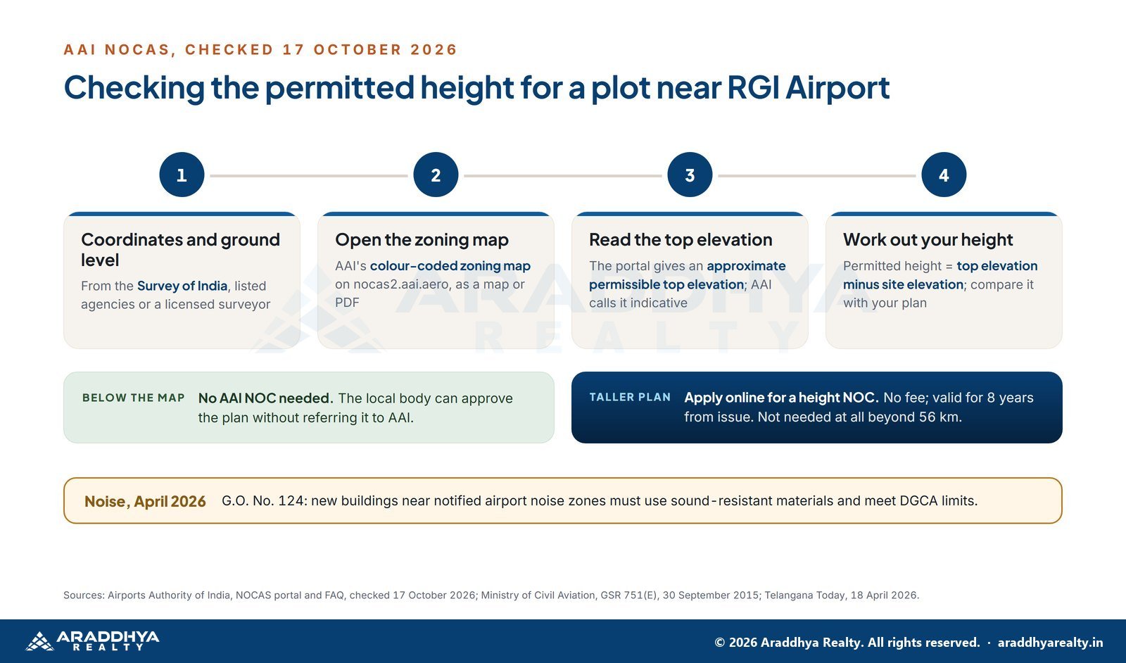
- Get the plot’s coordinates and ground level. AAI’s FAQ says site coordinates and elevation may be obtained from the Survey of India or listed agencies and licensed surveyors.
- Open AAI’s NOCAS portal. It publishes colour-coded zoning maps for major airports, as an interactive map or a PDF, at nocas2.aai.aero.
- Find the permitted top elevation. The portal’s tool gives an approximate permissible top elevation for your coordinates. Your permitted height is that figure minus the site elevation, and AAI calls the result indicative.
- Compare it with your plan. If your building stays below the map’s height, AAI says no NOC is needed and the local body can approve it without referring to AAI.
- If you want to build taller, apply online. AAI charges no fee for a height NOC, and an NOC is valid for eight years from issue.
The rule basis is the Ministry of Civil Aviation’s height restriction rules of 30 September 2015. For a sense of scale, NOCAS also says no height NOC is needed for any structure beyond 56 km from the facility.
Aircraft noise and the April 2026 building rule
Noise is the other side of living near a runway. G.O. No. 124, issued in April 2026, amended the Telangana Building Rules 2012. New homes, hospitals, institutions and commercial buildings near notified airport noise zones must now use sound-resistant materials and meet DGCA noise limits. It applies to new construction only.
We could not find a published map of the notified zones, so we make no claim about any village. Ask the local body whether a plot falls in a notified zone, budget for the materials if it does, and visit at different hours to hear it for yourself.
Approvals to check near the airport
Being near the airport says nothing about whether a plot is sound. Three checks matter more:
- The authority for that village. HMDA, FCDA and GHMC all appear in the table above, sometimes a few kilometres apart. Ask for the layout permission number and verify it with the authority that issued it, such as HMDA.
- The local body after the 2025 mergers. Shamshabad, Tukkuguda and Adibatla were among 27 urban local bodies merged into GHMC, approved in November 2025, so confirm who will collect property tax and issue building permission.
- Title and TG-RERA registration. Check the survey number on Bhu Bharati and the project on rera.telangana.gov.in. Our verification checklist walks through each step, including the encumbrance certificate and the farm plot rules.
What waiting costs you when the airport drive matters
If the airport is why you are looking here, the cost of waiting shows up in hours, not prices.
- Every month of a long commute is real time. A crew member or shift worker renting across the city spends those hours on the road now, and a plot shortens the drive only once a house stands on it.
- The airport’s own plans are years out. GMR’s expansion, a larger terminal, a new terminal and a second runway, was reported on 24 August 2026 as a five to seven year plan, and the airport to Future City metro is still proposed. The ORR, which carries most of the drive, is built today, so decide on the measured drive.
- Checks take days to weeks. A late start means pressure to pay an advance before the layout permission, encumbrance certificate and title opinion are back.
- Registration follows the value on the registration date. The Ready Reckoner links market value orders of 2021 and 2022, and values were revised statewide again from 5 June 2026. No next revision is announced, but a deed registered after any revision is charged on the new value; our market value guide shows how to check it.
- Choice narrows as plots are booked. East-facing, corner and park-facing plots are usually chosen first in any layout, and weekend visit slots need booking ahead.
Illustrative: Sameer works 5 am shifts at the airport and rents on the far side of the city, about an hour away on a good day. He put off visiting plots for a year to “see what the metro does”. At the end of that year the metro was still a proposal; the hour each way was not.
Working airport shifts? Message us on WhatsApp with your shift times, and we will suggest a visit slot and a timed drive that fit them.
What is changing around the airport belt (status as of October 2026)
Here is the dated status of what is built, being built and only planned around RGI Airport and the villages in our table.
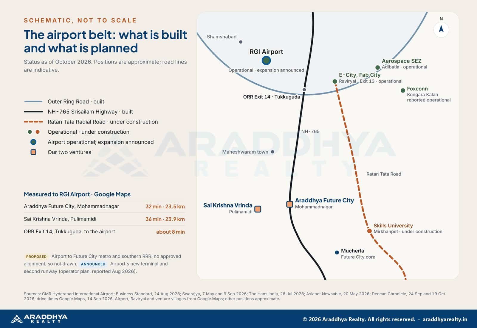
| Project | What it is | Status | Date / source |
|---|---|---|---|
| RGI Airport | Single terminal, capacity about 34 million passengers a year | Operational; 30.48 million passengers in FY 2025-26 | Operator figure, September 2026 |
| RGI Airport expansion | Larger and new terminal, second runway, about 80 million a year | Announced (operator plan) | Reported 24 August 2026 |
| Outer Ring Road | 158 km ring; Exit 14 to the airport about 8 minutes | Built | Measured 14 September 2026 |
| Airport to Future City metro | 39.6 km line | Proposed; awaiting central approval | Swarajya, 7 May 2026 |
| Ratan Tata Greenfield Radial Road | 41.5 km, 100 m corridor, ORR Exit 13 to Amangal | Under construction | HMDA target May 2028 (Swarajya, 9 September 2026) |
| E-City and Fab City, Raviryal | Electronics and industrial parks | Operational | Units operating, July 2026 |
| Aerospace SEZ, Adibatla | Tata aerospace units | Operational | Tata unit since March 2010 |
| Foxconn Interconnect Technology | Plant at Kongara Kalan | Reported operational | Statement reported 20 May 2026 |
| Bharat Future City and FCDA | Authority for 56 villages | Operational; master plan in preparation | G.O.Ms.No.69, 12 March 2025; plan due December 2026 |
| Young India Skills University | Permanent campus, Mirkhanpet | Under construction | Chief Minister’s review, 19 October 2026 |
| Regional Ring Road, southern part | 201 km, via Amangal | Proposed; no central decision | 24 September 2026 |
For an airport household, the useful point is that the drive depends mostly on roads already built: the ORR and NH-765. The airport’s expansion would add capacity inside the airport, not shorten the road to it, and the metro has no approved alignment. Jobs near the belt operate today at the airport, E-City, Fab City and Adibatla, while the Future City projects to the south-east are under construction. Schools and hospitals tend to follow homes over years, so expect to use Shamshabad, Maheshwaram town or the city at first.
From Araddhya Future City at Mohammadnagar, RGI Airport measured 32 minutes (23.5 km) and ORR Exit 14 24 minutes; from Sai Krishna Vrinda at Pulimamidi, the airport measured 36 minutes (23.9 km), on Google Maps on 14 September 2026. Our Future City development tracker and guide to the southern growth corridors follow each project, and our Regional Ring Road guide explains why the southern RRR is still a proposal.
Want to see the layouts before the timed drive? Take the 360° virtual tour of both ventures from home, then book the drive.
What this means if you are buying a plot
Here is an illustrative scenario. Farhan and Divya work early shifts at the airport and were offered a “15 minutes from RGIA” plot at a premium. Before paying, they drove it at 5 am and again at 6 pm, and neither drive came close to 15 minutes. They then compared layouts in the 30 to 36 minute band on equal terms, approval against approval, and bought where the papers checked out. Their relief came from knowing the number on the brochure matched the number on the clock.
That is how we think airport proximity should be sold: with a measured time and a date. Both our ventures publish theirs. From Mohammadnagar, RGI Airport measured 32 minutes, and from Pulimamidi 36 minutes, on Google Maps on 14 September 2026. Neither figure is 15, and we will not tell you otherwise. Weekend visit slots need booking ahead, so tell us early if Saturday suits you.
Your next step
- Write down your real travel hours: shift starts, flight times and the school run.
- Shortlist villages from the measured table, then ask each seller for a dated drive time from the plot gate.
- Verify the layout permission with the issuing authority and the project on the TG-RERA portal.
- Check the permitted height on NOCAS if you plan more than a family home.
- Drive the route at your own hour before you pay anything.
This guide is general information, not legal or technical advice. Drive times change with traffic, road works and the hour you travel. Height limits and noise zones are set by AAI, DGCA and the local body, so confirm them for your exact survey number and building plan before you buy or build.
There is a quiet joy in a short, predictable drive home after a late landing or an early shift: the ORR lights, the turn onto your own road, the gate you chose because the clock agreed with the brochure. That is what a plot near the airport should give you, and it deserves checking properly.
Plan your next step
Is the airport drive the deciding factor for you? Araddhya Realty is a TG-RERA registered agent (A02500007890). Book a free site visit and we will drive from the plot to RGI Airport with you at the hour you would actually travel, with the clock running, and show you the approval papers for each layout on the way. Book a timed airport drive. Prefer WhatsApp? Message us on WhatsApp.
Frequently asked questions
From the plot villages beyond the ORR that we measured on Google Maps in September 2026, RGI Airport took 30 minutes from Adibatla, 31 from Kothur and Lemoor, 32 from Mohammadnagar and 36 from Pulimamidi. Weekday peak trips can take longer, so time the drive at your own travel hour.
None of the eight villages we measured beyond the ORR came close. The nearest, Adibatla, took 30 minutes on 27 September 2026. On our 14 September 2026 run, ORR Exit 14 at Tukkuguda to the airport alone took about 8 minutes, so ask any seller for a dated, measured figure from the plot gate.
Usually not for a typical home. AAI’s NOCAS portal says no NOC is needed for a structure below the height on the colour-coded zoning map, and local bodies can approve such plans directly. A taller building needs a height NOC, which AAI issues online without a fee.
Get the plot’s coordinates and site elevation from the Survey of India or a licensed surveyor, then use the approximate permissible top elevation tool on AAI’s NOCAS portal. Subtract the site elevation from that figure to get the indicative permitted height, and confirm it with the local body before you plan.
G.O. No. 124, issued in April 2026, amended the Telangana Building Rules 2012. New homes, hospitals, institutions and commercial buildings near notified airport noise zones must use sound-resistant materials and meet DGCA noise limits. It applies only to new construction, so ask the local body whether your plot is in a notified zone.
It depends on the village. In our table, Adibatla and Pulimamidi are in the HMDA region, while Kothur, Lemoor and Mohammadnagar have been under FCDA since 12 March 2025. Shamshabad and Tukkuguda also merged into GHMC as local bodies, so confirm both the layout authority and the local body.
Araddhya Future City at Mohammadnagar, Kandukur, measured 32 minutes (23.5 km) from RGI Airport, and Sai Krishna Vrinda at Pulimamidi, near Maheshwaram, measured 36 minutes (23.9 km), both on Google Maps on 14 September 2026, first suggested route, outside the morning peak.
Neither has a date that would change your drive soon. The airport to Future City metro was proposed and awaiting central approval in May 2026, and the terminal and second runway plan reported on 24 August 2026 runs over five to seven years. The ORR and NH-765 carry the drive today, so time it yourself and verify the layout approval before you decide.
Sources. Google Maps drive times, first suggested route: 14 September 2026 (Mohammadnagar, Pulimamidi) and 27 September 2026 (Adibatla, Kothur, Lemoor, Kadthal, Mucherla, Yacharam) · Airports Authority of India, NOCAS portal and FAQ, read 17 October 2026 · Ministry of Civil Aviation, GSR 751(E), 30 September 2015 · Telangana Today, G.O. No. 124 on airport noise, 18 April 2026 · G.O.Ms.No.68 and G.O.Ms.No.69, MA&UD, 12 March 2025 · The News Minute, GHMC merger of 27 urban local bodies, 25 November 2025 · GMR Hyderabad International Airport, FY 2025-26 traffic · Business Standard, airport expansion plan, 24 August 2026 · Swarajya: metro request, 7 May 2026; Ratan Tata Road, 9 September 2026 · Deccan Chronicle: master plan at the December summit, 13 October 2026; Skills University review, 19 October 2026; RRR south status, 24 September 2026 · Asianet Newsable, Foxconn Kongara Kalan, 20 May 2026 · The Hans India, E-City units, 28 July 2026 · Business Today, 29 January 2015, and Tata and Boeing newsrooms, 1 March 2018, on the Adibatla aerospace units · Ready Reckoner, read 17 October 2026 · Araddhya Future City and Sai Krishna Vrinda project pages, read 22 October 2026.
This article is general information, not investment or legal advice. Figures are dated and change often. Verify approvals and project registration yourself at rera.telangana.gov.in and with the issuing planning authority before any purchase.
Useful next reads. the ten checks before you pay; how the southern corridors compare; which approval applies where; how to test a brochure claim; areas we cover; buyer questions answered; all our guides.
Disclaimer · Privacy policy · Terms of use · Araddhya Realty home